Article Kelly Stijkel and Jenni Ferguson
Images Kelly Stijkel, Jenni Ferguson and Chris Cragg
After an early start, we turn off the Juliasdale-Mutare Road onto the Honde Valley Road winding down into the fertile and lush Honde Valley. There is a constant change of scenery, from the pine trees to subsistence farming of bananas, mangoes, avocados, papayas and peaches. There are few places in Zimbabwe where you can buy a big bag of mangoes or an entire banana branch for just one bond!
The Honde Valley has the Zimbabwean touch – friendly people sharing all their joy. Looking up to the escapement, one can see the mighty Mutororo and Mutarazi Falls, Zimbabwe’s highest waterfall, cascading down in all their beauty. This region also boasts the highest mountain, Mount Nyangani where it is said that the mere whisper of a word in some places will cause you to disappear. It’s remarkable that within one hour of a drive you will witness both of these magnificent sights.
Following this road, passing the hundreds of goats, the very equipped town of Hauna and the gushing Pungwe River, you will eventually arrive at the Eastern Highlands Plantations.
Green. Lush. That’s the only way to describe the vast array of tea covering every slope in sight. Described by visitors as ‘heaven on earth’, these words are nothing short of the truth. Once we arrived at Aberfoyle Lodge, the friendly staff, all of whom seem to have been born and raised in the Honde Valley, welcomed us.
Aberfoyle Lodge was completed in 1960 as a club for the tea estate staff and later converted to a 15 bedroom fully-catered lodge which is now managed by Far and Wide Zimbabwe. It still has the original wooden floors, large verandahs and old-fashioned comfort but with new décor and very comfortable ensuite bedrooms.
Each of these bedrooms are named after the unique birds found here, with the colours of the walls matching the respective bird. Aberfoyle has undergone three phases of renovations in the last 8 years, and it shows! Aberfoyle Lodge really encompasses every-thing to do with the beauty of the outdoors.
With its offerings of zip lining through the trees, sliding down a ten-metre bum slide or white water rafting; hiking through the riparian forest or learning about the history of the Eastern Highlands Plantation through a tea factory tour; or birding with brilliant guide we able to truly explore ‘Zimbabwe’s hidden gem’. Enjoying a lengthly drive west brought up the Nyangwe Fort; the home of a people with a more settled way of life who started to infiltrate the country two thousand years ago. What, at first glance, looked like an arrangement of stone, was in fact the representation of those who were able to live as settled communities. It was these people and their descendants who were responsible for the great number of prehistoric structures for which the Nyanga District is most famous.
The surrounding areas contain many archaeological remains of people from this time who lived by the stone-built pit structures and who built stone forts on the heights. The people of this time lived in the warmer valleys and only retreated to the heights for safety. Nyangwe Fort, located near Mare Dam in Nyanga National Park,
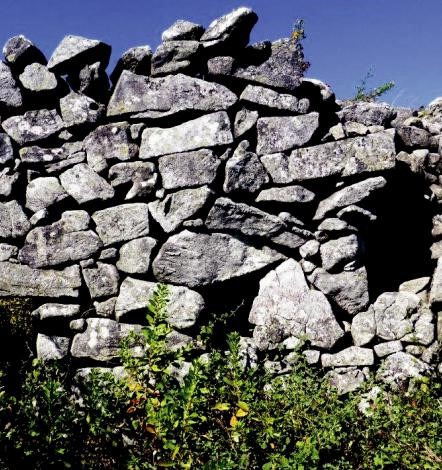
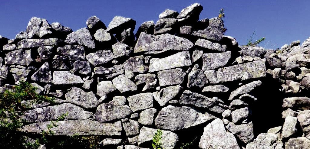
is the largest, most intact, and probably the best example of the Uplands Type 8 Fort in Nyanga. Its massive stonework is a fine example of Nyanga ruins built some 400 years ago.
Chawomera Fort, visible from Nyangwe, is of similar construction and hails from the same time period. Nyangwe Fort is in a commanding situation; it enjoys wide views over the valley towards Mount Nyangani, whilst crowning a rocky promontory surrounded by steep drops and sharp rocky slopes.
The summit is crowned by the original enclosure, which is surrounded by five further enclosures. All have loopholes, arrowslits built into the wall and most contain low stone circles of hut bases. The main features of the Fort are the tall walls, consisting of large, close-fitting blocks of stone which form enclosures characterised by low lintelled entrances.
The Fort was visited by Dr Heinrich Schilicher in 1897 and Dr Carl Peters in 1900, who both proposed exotic theories of ancient Semitic origin. RN Hall attributed them to ‘Arabs’ of the 11th or 12th centuries from the East African cities of Mogadishu and Kilwa. Dr Randall Maclver, a professional archaeologist brought out by the Rhodes Trustees, ascribed all the Rhodesian ruins to Bantu speaking peoples, living between the 13th and 17th centuries. The late Peter Garlake once commented that there was bitter controversy between the disciples of Peters, Hall and Maclver on the origin of the ruins.
Roger Summers and Keith Robinson only put this controversy to rest in 1948 when the Inyanga Research Fund sponsored a series of excavations. Their results were published in 1958 by Summers in Inyanga: Prehistoric Settlement in Southern Rhodesia. Study of the archaeological finds from the ruins consisting of beads, pottery, bone and metalwork makes it quite clear that no site shows any exotic Semitic or Arab influence. Another controversy surrounded the loopholes in the Fort walls, which were associated by early archaeologists to Fort Sao Caetano of Sofala. This started endless speculation as to the origin of these monuments which controversy again only ended with the excavations by Summers and Robinson in 1951.
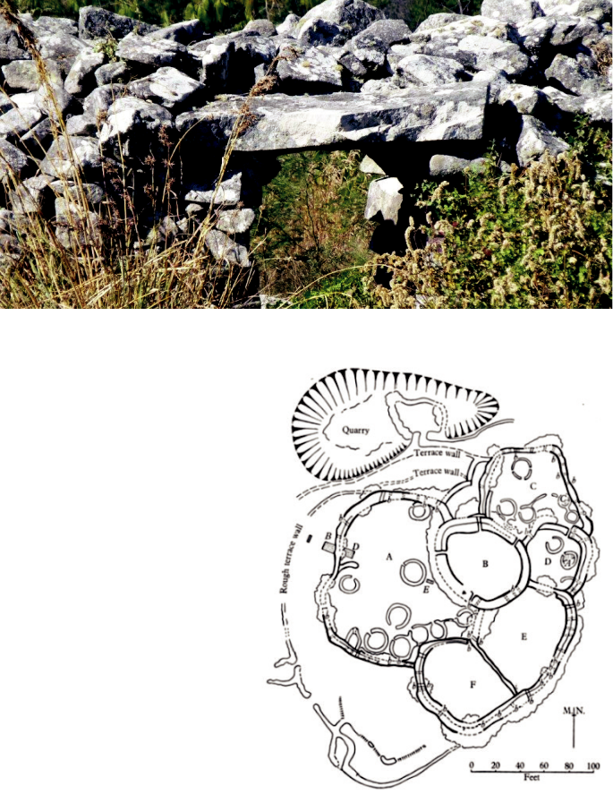
Roger Summers believes the original enclosure (see map) was (B) to which (E) and (F) were then added. Then came then (D) and finally (C). Within these enclosures, there are low stone circles – the remains of huts and granaries. They are believed to date from around the 16th century when the climate of the Nyanga Uplands seems to have been drier than today, enabling grain crops to be cultivated.